
Features ATAK Plugin: TAKSat
ATTENTION: This is an ATAK Plugin.
To use this extended capability, the ATAK baseline must be installed.
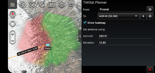
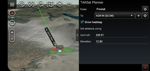
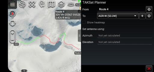
Download the ATAK baseline here: https://play.google.com/store/apps/details?id=com.atakmap.app.civThe TAKSat Planner tool calculates the Azimuth and Elevation required to achieve communication with a Geostationary satellite.
When available, it uses Digital Terrain Elevation Data (DTED) to determine terrain masking and whether communications are likely to be achieved.
This can be from a fixed point or along a route.
The tool can also generate a heatmap around a selected ground location to determine where in the local area communications are likely to be achievable from.The plugin is pre-loaded with Immarsat BGAN satellites but users are able to quickly add other satellites.A PDF manual for the plugin can be found at -> "Settings/Tool Preferences/Specific Tool Preferences/TAKSat Planner Preferences".Best efforts are being made to keep the Open Beta Testing of this plugin updated to the same version as ATAK-CIV.
Therefore if this plugin is outdated compared to your ATAK installation please consider signing up as a Beta Tester.
Unfortunately, whilst feedback is appreciated, we can give no guarantees that requested features will be implemented.
Gaming Features
Enjoy immersive gaming experience with various game modes.
Food & Dining
Discover recipes and order food from your favorite restaurants.
Shopping Features
Shop online and find the best deals.
See the ATAK Plugin: TAKSat in Action
Get the App Today
Available for Android 8.0 and above